Our first day was a long day: I worked until 1pm, ran home, helped Walter lock up, put the trash out, etc. Our two planes got us to Irvine around 10.30pm Pacific time, but it was easily 3am the next day Washington DC time when we finally were ready for bed in our Irvine hotel. The next day we met up with the family, and enjoyed chatting with Daniel before his big day tomorrow.

Here's Walter and I bright and early on Saturday, the proud grandparents, ready to celebrate Daniel’s special day.

Daniel did really well reading the Torah and leading the service.


Both Daniel's parents made touching speeches, standing next to him with all their love and respect, as well as a great sense of humour.

His party was a blast: good food and drink and a great DJ who kept the kids dancing and playing games while the adults nattered away, or watched the energy and excitement out on the dance floor. And of course there was Daniel's favourite dance with his mother!

We spent another two days with the family in Irvine, including our personal tribute to Daniel, a lunch in a beautiful private resort restaurant overlooking the ocean for ten of us.
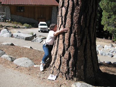
Finally it was off north: Walter drove well through challenging rush hour traffic in the Los Angeles region, and I took up the drive via Sequoia National Park where we visited the world’s most voluminous tree, General Sherman. You can see from the photo below, how little we are in comparison to the base of the tree, also the size of the giant redwoods in the second photo in comparison to the other evergreens in the forest!


Our hotel was in Oakhurst, 16 miles from Yosemite National Park, however, the road immediately starts to turn and twist upwards on a one-lane highway, turning this short trip into almost 45 minutes. Then once past the entrance to the park there’s another hour or so of driving at 25-35 mph to reach the Valley, watching for bears, deer, falling rocks, hikers, and wayward drivers whether on bikes, motorbikes, in a car or bigger.
From the moment we reached the entrance to Yosemite Valley, it was one photo op after another. Here are a few:
El Capitan:

Half Dome:


The back of the Half Dome resembles a Greek warrior... or some giant's face in the sunlight!


My first treehugging episode. I liked the smell of vanilla coming from the bark!
For our first day, I’d gotten us seats on the Grand Tour coach. It was a day-long tour, taking us to all the best vantage points for the main attractions, and included an open trolley tour of Mariposa Grove, where all the red firs, white firs, ponderosa pines, incense cedars and sequoias hang out. It was amazing to lean back and look up at these 340 foot giants, or to walk through the base of one of them. The sequoia is protected by its incredibly thick bark, does not fall prey to insects, its branches start very high up, thus avoiding the floor fires that can start. Because of its height, it gets the most light to keep growing. The trees that can be seen today are around 2,200 years old, but they’ve been around for much much longer than that. They reproduce only through fire (a contradiction in terms, as fires can kill trees) – the heat opens the small pinecones thus releasing the seeds which then can grow into a tree. Our guide was superb, but I was confused by all the different types of evergreens and conifers! However, we came away in awe of such majestic trees – the grove was a veritable cathedral of trees and light.


We ended the tour with photos opposite El Capitan, with the Half Dome in the distance. Earlier, we’d been at Glacier Point after a long coach ride, with the Half Dome so much closer in the background.

We stayed in Yosemite to have supper, and so set out for Oakhurst just as the sun was setting. I was driving, and saying to Walter how sad I was that I hadn’t seen a bear all day, when five or ten minutes later, a smallish hairy black thing on all four legs quickly lollopped across the road about 25 feet in front of me and disappeared into the bushes. No doubt in my mind: it was a bear! According to the park ranger the next day, the size I described to him meant that it was a cub.
Our next day was one of exploration. We walked over to Yosemite Falls, a mere trickle at this time of year, but still impressive with its height. Then we started up a steep trail which hugged the bottom of the mountain. After the first few minutes, we lost the noisy tourists, and had the trail to ourselves.


Some of the trees (unclear which they were) had the most beautiful abstract patterns on their bark:

We came out 40 minutes later opposite a beautiful meadow, behind which was the mountain backdrop with the Half Dome. It was picture perfect!


The meadow area had lots of wild animals in it. Here's a particularly graceful one:

Blessed are those with summer houses at the side of the meadow with such a stupefying view. (I’m running out of superlatives!)
We continued our walk until we reached a certain amphitheatre in a campground, where a park ranger talked to us about bears, and took us on a short walk to show us how to keep the bears safe and out of trouble. Black bears (they can be anything from white, cinnamon, dark brown, inky black in colour) are smaller than the grizzlies. But they still need from 5,000 to 20,000 calories PER DAY to survive. Their sense of smell is 100 times that of a human, and they will break into cars and rip open cans of food. They’re so clever they can tell the difference between a suitcase and a cooler full of food. One such bear, seeking the fast route to getting his calories for the day, ripped open the boot (trunk) of a car full of beer. There was a load of good imported beer and a load of not so good local beer. He drank all the good beer and left all but one can of the local beer. The rangers found him passed out the next morning, overdosed on liquid bread!
Everywhere you see “bearboxes” at the start of trails for people to ‘lock’ their food in a bearproof metal storage cupboard. Everywhere you would see bearproof trash and recycling bins.
Our ranger told us about a day in his life when he was helping quell a fire in one part of the Valley, when he heard rocks fall. He rushed off to see what could be done, then received a call to chase a bear away from a camping site. He likes his job! He is especially fond of bears. The bears are shooed away from humans and human food so that they do not become lazy and eat the wrong food. The bears are left alone in the wild to find their grubs, acorns, grass and other goodies. But I think a bear needs to eat a horrible amount of acorns and berries to get their 5-20 THOUSAND calories each day! Luckily they hibernate for some of the winter, so the scavenging is not the whole year round, but it’s still most of their life.
Some water photos from Yosemite:
A beach:

A romantic water scene:

On our last day, I got up early and drove out to Yosemite again, this time on my own, for a 4 hour mule trip into the wilderness of Yosemite. I’d been looking forward to this trip ever since I read about horse and mule rides in the Park.

Helmets on, mules chosen for us according to our height and experience, we were given a quick lesson on handling a mule. At 1pm we started off. At 1.08pm I was in the car phoning Walter to tell him I had cancelled my mule trek. As we were all leaving the stables on our mules and crossing the road to walk up a trail in front of us, my mule started to go backwards. I did all the kicking I could to get him to go forward. He didn’t obey. Nor did he obey my rein-pulling. In fact he started to turn back to the stables very quickly, and my shouts brought one of the mule handlers over, but my mule was determined to go faster and haphazardly, making me very scared of falling off or being thrown. With help from the handler, I dismounted and left the stables very disappointed. (Yes, I got my money back!)
So instead I drove slowly around the Valley one last time and took a different route back, along the beautiful Merced River, through a quaint little town called Mariposa (Butterfly!). I took a couple of interesting photos (a lot of religion in Mariposa!):


Went into some antique shops, then returned to the hotel early and we ate in a local Chinese restaurant where the staff were velly velly happy to see us, and asked us whether we wanted flied or steamed ‘lice’ with our kung pao chicken.
The next day we were up and off very early for Concord in the San Francisco Bay area. Walter and I shared the 4 hour drive to Carol’s home and we spent the rest of the weekend with her and our grandchildren, with a trip into San Francisco to visit the Contemporary Jewish Museum (GREAT gift shop!!) and the SF Museum of Modern Art. We ate downtown at a bustling Mexican restaurant: Colibri. Food (AND the tequilas) was delicious.
Monday morning we left the house before the busy residents.
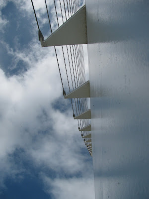
Our goal was Crater Lake, across the border in Oregon, a 6 or 7 hours drive away. Walter drove us to Redding, approximately half way, where we made a stop to visit the Sundial Bridge – a pedestrian and bicycle bridge over the Sacramento River, designed by Santiago Calatrava and completed in 2004. The bridge is in the middle of a beautiful nature park with activities and educational events for children and adults. A nice café complemented the picture. Photos can’t really describe the peaceful location and the brilliant engineering of this impressive structure. Fishermen in the river, anchored to something because of the strong current, swallows swarming above and perching on the thick cables holding up the ‘mast’-like structure at one end of the bridge, the blue-green special glass floor of the bridge. The shadow of the ‘mast’ falls on special mosaic-tiled ‘bumps’ for each hour. Apparently the clock is exact only on June 21, the summer solstice. But it was only a few minutes off when we saw it on September 14. An amazing place to go visit.




As I drove us through the rest of the day, further north to the California/Oregon border, the scenery became more ‘Scandinavian’. Lots of hillsides with evergreen trees. Our last stop in California was WEED (named after the first timber company owner back in 1909 or so), so we just had to wee in Weed so that we could say we weed in Weed!
We made it to Crater Lake in record time, and had enough time before dark to take a drive around the best parts of the 33 mile long rim. We marvelled at the deep blue waters of this 5 mile wide caldera formed after a 12,000 foot high volcano blew its top then collapsed some 6,800 years ago. Snow melted into the lake, and rain and seepage over the years, make this into a very spectacular lake, with a smaller volcano that had created its own island in the lake: Wizard Island. Crater Lake is deep: at 1,943 feet, it's the deepest in the United States. It's also one of the bluest anywhere, thanks to its great depth and the exceptional clarity of the water, which interacts with the light to absorb red, yellow and other colors of the spectrum but reflect back the blue.
Sadly we realized that we would not have time to do the boat trip in the lake and to Wizard Island the next morning, so we contented ourselves with a sunset from a spot overlooking the phantom ship, a formation of dense lavas, possibly over 400,000 years old.


Our cabin at Mazama Village near the rim was nice. VERY quiet, and surrounded by pine and fir trees. No TV and no phones. There wasn’t even a signal on my Kindle e-reader, which can pick up a signal anywhere in the US normally.
Supper was grand: at the Crater Lake Lodge, an incredible building which was built between 1909 and 1914, and opened in 1915. Crater Lake Lodge was built to encourage tourism to Crater Lake National Park and southwestern Oregon.
Although business profits lagged due to high operational costs, Crater Lake Lodge drew large crowds. Early 20th century visitors probably accepted the substandard accommodations because of the rigorous trip needed to reach the park. Though the lodge lacked amenities and atmosphere, visitors were compensated by the magnificent views of Crater Lake and the surrounding peaks of the Cascade Range.
When it was enlarged and upgraded from 1922 through 1924, the number of guest rooms more than doubled. Plumbing was expanded, and as a result most of the rooms in the new annex and annex wing had private bathrooms. However, a lack of investment capital plagued the expansion. Many guest rooms were left unfinished. The lodge suffered with the decline in visits and business during the early 1930s, the worst years of the Great Depression. Little was spent to keep up the facility.
Both the park and Crater Lake Lodge were closed for most of World War II. After the war, park visitation increased dramatically, as did business at the lodge. However, age and many years of neglect took a heavy toll on the building.
Throughout the 1950s and 1960s, the National Park Service continually prodded, with mixed results, the lodge’s owners to upgrade utilities and fire prevention measures. After fifty years of severe winters on the caldera’s edge, the lodge’s inadequate structural system was showing signs of advanced deterioration. Cables stretched between the north and south walls to try to keep them from bowing. Floors and ceilings were sagging, and cracks appeared in the masonry. Only small amounts of money were invested in piecemeal fashion to keep the lodge open every summer. This Band-Aid approach left utility systems and life-safety measures lagging behind contemporary codes and standards.
The National Park Service acquired ownership of Crater Lake Lodge in 1967, but the building continued to deteriorate. Despite being listed on the National Register of Historic Places, the National Park Service felt that it was too expensive to fix and maintain. The agency failed to implement a proposal to demolish the building once it found public opinion to save the lodge too strong. Consequently, the agency approved a plan to save Crater Lake Lodge as part of the comprehensive Rim Village Redevelopment Program in 1988.
Engineers contracted by the National Park Service monitored the structural integrity of the lodge through the 1980s. In the spring of 1989, just before the lodge was to open for the summer season, the engineers advised the park that the Great Hall wing was unsafe for occupants. They predicted this part of the building might collapse of its own weight, bringing down the rest of the lodge with it. This compelled the National Park Service to keep the lodge closed and begin a comprehensive rehabilitation project.
The plan to rehabilitate Crater Lake Lodge called for returning the exterior appearance and interior public areas to that of the late 1920s. After nearly two years of planning and design, construction work began in 1991. Some original materials, such as the masonry stones, were salvaged for reuse, but very little of the original building could be saved. The Great Hall wing was dismantled and rebuilt. Most of the rest was gutted. A steel structural support system, utilities, life-safety systems, and modern hotel standards were built into the new facility. The rehabilitation of Crater Lake Lodge was completed in the fall of 1994 at a cost of more than $15,000,000.
Huge open log fires, all wood panelling and floors, excellent food and wine. Walter promises me that we’ll stay in the Lodge next time. (Though I noted that they too don’t have TV or phones in their rooms, some of which were almost double the price of the cabins. Hee hee!).


The next day we drove north through the middle of Oregon. Different ecosystems, from forest, to wilderness, to fruit orchards, all surrounded by various hills and mountains of the Cascades range. Several snow-topped mountains dotted the landscape. No sooner had we lost one from view, than the next one could be seen on the horizon. The Bachelor and the Three Sisters graced our lunch spot just before the town of Bend. Then Jefferson, Grizzly Mountain, and finally Mt Hood, lording it over the whole area at over 11,000 feet. We didn’t have enough time to visit the Fruit Loop – a triangle of roads around the base of Mt. Hood where the different orchards flourish – we had to press on to The Dalles (an early trading post on the Columbia River) where we stayed downtown and walked along the main street, some of which were shops long gone out of business, and others with incredible antiques, inexpensive, just waiting for people to discover them. All these antique shops were already closed by the time we stepped out along the main road, but we found Oregon’s oldest continuously trading bookstore, Klindt’s, celebrating its 140th birthday – 10 years younger than the State itself. A great selection of old and new, and lots of books on the area and on Oregon. Then it was on to the Baldwin Saloon – a restaurant and bar with character and history. You could just imagine the Wild Westerners coming in there during the fur trade and the end of the Gold Rush, and the showgirls putting on their dancing act!
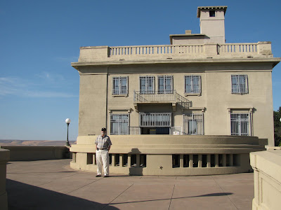
The next day was our day for discovering the Columbia River Gorge. First we went east and across into Washington State to a museum overlooking the river: Maryhill. Whilst most of it didn’t interest us too much, it does have a most comprehensive and spectacular exhibit of native American crafts and everyday utensils; beautiful basketry; beading of clothes, moccasins, gloves, capes made from cedar bark; tools for skinning animals, catching fish, sewing; baby carriers; load carriers; Also old photos of native Americans in their clothes, cooking, weaving, their camps, etc.
The first to greet us were seven peacocks in the garden:

The view eastwards from Maryhill:

The view westwards from Maryhill:

Walter outside Maryhill:
One of the exhibits was from the Théâtre de la Mode. In 1939, there were seventy registered couture houses in Paris, including the grand establishments of Chanel, Schiaparelli and Balenciaga. This flourishing industry was disrupted by the wartime occupation of Paris. Private clients dispersed, international sales almost ceased and many couturiers closed. The Germans planned to move couture to Berlin but Lucien Lelong, president of the Chambre Syndicale de la Couture Parisienne, objected, saying, 'It is in Paris or it is nowhere'. In 1945-6, the Paris couturiers created the Théâtre de la Mode, a touring exhibition of nearly two hundred dolls in sets, created by artists such as Christian Bérard and Jean Cocteau, their fashions designed and sewn together by the top couture houses. The Théâtre toured to Britain, Scandinavia and the USA, raising funds for war victims and promoting French fashion. This is a famous collection, some of which I had seen at the Victoria & Albert Museum in London.

A fascinating exhibit at Maryhill was its collection of chess sets, from early English, to modern African, late 19th century ivory from India, and other materials:


We then zigzagged across the Columbia River: back into The Dalles and to Hood River, watching the parasailing and the windsurfing in the middle of the huge, choppy, windy river.
Then back into Washington State to follow the river highway there.
The views of Mt. Hood from alongside the Columbia River Gorge were magnificent.


Looking back to where we'd come from:

Still to travel:

Then back into Oregon and a visit to the Bonneville Dam where we visited the older of the two hydroelectric power stations, and the salmon observation floor, where we could watch these huge salmon through glass windows below the water rushing over steps. The salmon, rather than leap upwards over the steps, chose to go through holes inside the steps to make their way upstream! The US Corps of Engineers made sure that the two power stations didn’t inconvenience the salmon in their quest to make their way upstream to spawn.


Then the waterfall areas: Multnomah Falls, where I climbed up to the bridge part way up:


Also close to the highway: Bridal Veil, Horsetail, and Latourell Falls
Most of the way I was driving along the Historic Columbia River Highway, built between 1913 and 1920, hugging the mountains overlooking Oregon’s riverside, not wanting to take the easier Interstate highway. Through little forests, around tight bends with old parapets, observation points to admire the immensity and beauty of the whole river area. This was a work of art as well as an engineering marvel, with originally 73 miles of road, 18 bridges, 7 viaducts, 3 tunnels and 2 footbridges all combined into the first major paved road in the Pacific Northwest, five years after the first Model T Ford rolled off the assembly line.
The weather, once hot sun at the start of our trip at Maryhill, turned grey, and dark. By the time we got to our last stop – Vista House – the Gorge was slowly disappearing to our left and our right, but I managed to capture the last sunlight on hills way to the east.


Then it was non-stop to Portland and a friend’s house there. Luckily, despite the black clouds, it was only drizzling.
Not content to explore locally, we ventured out in our car to the downtown area where we wanted to try a good restaurant, Higgins. Because of the one-way grid system, we got horribly lost, but eventually found the place. Great food and ambiance, but VERY noisy, and Walter and I could only look at each other and mouth words.
To get home was difficult, but nothing compared to our next evening out, when we kept going back and forth over the Willamette River and onto freeways and were so lost that finally a Portland police officer escorted us to our ‘restaurant’ of choice: Pok Pok, a thatched eating area and small restaurant, serving Thai food. We chose take-out so that we could rest assured that we got home and then ate, rather than eat there, worrying that we wouldn’t find our way home. Walter navigated by an illegible map while I drove. Luckily there was not much traffic, but it was still not easy to find our way. (I notice that the streets are all badly lit, and the street names are totally illegible, white on small, green signs, and they’re all similar: SW 105th Ave, SW 106th Ave, so you don’t have time to read them and differentiate between them before you’ve passed your turn!)
Our first day in Portland was a drive to the Pacific Ocean. On the way, we made a slight detour to meet up with our Mac dealer, from whom we’ve bought at least six Apple computers over the past ten years. Then we hit the coast just north of Lincoln City, and followed the 101 coastal road all the way up north stopping at Kiwanda Beach for our homemade sandwiches.

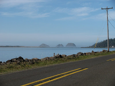
The Oregon coast is all public, and is basically wild and unspoiled.
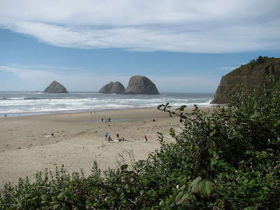

Small groups of houses along the wayside here and there, and the beautiful little town of Oceanside caught our attention en route, with houses going up a steep hillside.


We made a long stop in Tillamook and visited the cheese, ice cream and yoghurt factory there. We watched how the huge blocks of cheese came out from their ageing process (stored for a while at a constant 42oF) and were sliced and packed and boxed.

Watching from windows above, I felt we were watching Chaplin’s Modern Times, with conveyor belts moving everywhere with different sizes of cheese and stages of packaging. We of course sampled several of the products!
Continuing on, we found a deserted beach, Manhattan Beach, by walking through shoulder high grass and bushes.


Large haystack rocks and arches could be seen a few hundred yards out to sea in various places along the coast, until the mist moved in, and at the well-known Cannon Beach, we could only just make out one of several such large rocks.


Here's what it SHOULD look like!
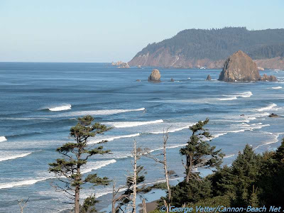

It was time to go back to Portland. That evening was the one we got the most lost ever, but thanks to a Portland police officer, as explained above, we found our little Thai take-out place, and more or less found our way home, by luck rather than with brains.
Friday September 18 we finally got to see Portland by light of day. Our first stop was at the Japanese Garden, an enclosed area inside Washington Park. Bridges, tea house and shelters, koi in ponds, waterfalls, zen gardens – all so meticulously cared for, so peaceful. And great views of the city and Mt. Hood from up there.


This was SO beautiful in reality, with the reflections of the water beneath the leaves dappling both leaves and branches:


From there to the Oregon Historical Society Museum where there is an excellent (I hope permanent) exhibit called ‘Oregon, My Oregon’ (the state anthem), showing the economic and demographic history of the State, how the Indians lived, how they were chased off their lands, killed, how the first settlers arrived, their crafts, clothes, tools, etc. There were two interesting films too, one of Oregon’s industry in the 1930’s, promising work to everyone, promising that crops won’t fail, promising people will get rich. A pick-me-upper following the Great Depression!
From there we took a streetcar to the Pearl District. (Portland is committed to keeping its downtown uncongested and to this end has invested heavily in its public transportation system. The single greatest innovation is that the three types (bus, streetcar and light railway) of public transportation are all free in “fareless square”, a 300 block area of downtown.) We got off at Powell’s Bookstore: not for nothing is it called The City of Books. It deals in new, rare, secondhand and out of print books. It’s divided into ‘rooms’, each one a different color. Within each huge room the bookcases reach almost to the ceiling. I dread to think how many tons of books are sitting on each square foot of floor! It stretches one block in every direction. There are over a million books in that one city block. When you go in, you get a map of the place, showing what topics are covered in each room, and on which floor each room can be found. Quite an experience!!
Our dinner after that was at a well-established (1892) seafood restaurant (Jake’s Crawfish). Again we got terribly lost going home!
Saturday is Portland’s Saturday Market – some 300 vendors outside in their tents and stalls: stuff for pets, loads of jewellery, food, pottery, palm readers, bands playing live music,
We bought just a mini-body pillow filled with catnip for our cat, Moët, but nothing else really appealed to us.
We walked through Old Town, China Town and through the Pearl District one last time. Then headed back to our house for the last time – this time, not getting lost! Ate in a family-run local restaurant, then came home to pack, ready for an early departure Sunday morning to Irvine, for our last day before returning to DC.
After driving over 2,000 miles in two weeks, we travelled back to our starting place in just two hours - by plane!
We had a few last hours with Steve, Karina, Jennifer and Daniel, then it was off to the airport the next morning, and an uneventful two flights home, except for a lightning change of planes in Chicago because of a delay, where we had five minutes between leaving our first plane and getting to the boarding gate of our next plane. We made it with a couple of minutes to spare, and so landed in DC at a reasonable hour and were home an hour later at 10pm. A befuddled Moët, one paw raised in hesitation, greeted us as we came in through the front door. And within a few minutes, she was all over us once more, having forgotten the last 18 days without us to pet her!

We were home!
No comments:
Post a Comment